
Clifton Neighbors Block Sources
Public sources around a Clifton address describe Clifton parcels and recorded Clifton roles, not every person associated with a building. Start with the Passaic County GIS viewer or its Clifton parcel service to see the target geometry and nearby polygons. Then use the Clifton assessment record and Clifton deed index to compare the same parcel identifiers. The order matters because a Clifton street number by itself can be incomplete or formatted differently across systems.
| Source | Block detail | Access route |
|---|---|---|
| Clifton / Passaic GIS | Clifton parcel shape, adjacency, PAMS PIN, block and lot, address, ZIP, use, values, and selected deed fields | Public Clifton viewer or REST query |
| Clifton assessor | Clifton owner, tax mailing address, situs, class, values, and qualifier | Clifton street, owner, block, lot, or qualifier search |
| Clifton PRESS search | Clifton recorded transfers, mortgages, liens, filed maps, rights-of-way, and street vacations | Online index; older and certified Clifton work at the county office |
| Clifton election-district list | Limited statutory voter-list fields for a Clifton district | Request from the Clifton elections custodian |
| Clifton planning or BOA record | Clifton addressed applications, applicants, block and lot, hearing, and resolution dates | Clifton agendas, documents, or a precise request |
| Clifton building request | Clifton address-specific work, occupancy, approval, or permit history | Clifton department or OPRA request; no public online search located |
| Clifton Library and PCHS materials | Historical Clifton street occupant or business snapshots | Onsite, licensed, or collection-specific Clifton access |
| Action Clifton Committee | Clifton civic neighborhood structure and contacts | Clifton city committee page; not a household roster |
Clifton owners and Clifton occupants are not the same category. A Clifton record can name an owner, trustee, estate, or entity without showing who is present at the Clifton address. For a broader Clifton address-by-address chain along a named road, use the Clifton street directory; the Clifton block method stays focused on immediately adjoining parcels.
Choose a Clifton Neighbor Parcel
Begin with the Clifton parcel, not merely a Clifton street number. In the Clifton GIS feature, retain the PAMS_PIN, PCL_MUN, PCLBLOCK, PCLLOT, PCL_GUID, situs, and ZIP before opening another Clifton record. Those identifiers connect a Clifton map feature to the Clifton assessment search and help distinguish two Clifton lots with similar addresses. The county parcel service also carries Clifton assessment, description, and selected deed fields that can support a careful comparison.
The Clifton map is a planning representation, not a survey, title opinion, or household list. Its Clifton polygon edge is useful for finding the parcels that share a boundary or front the same segment. A Clifton parcel on the opposite side of a road is nearby in ordinary speech but may not share a boundary. State the Clifton relationship precisely rather than using the word neighbor as if it supplied a legal definition.
- PAMS PIN
- A standardized New Jersey parcel identifier carried in the county GIS data.
- Block and lot
- Tax-map identifiers used to connect the GIS feature, assessment entry, and recorded-document search.
- Qualifier
- An added tax identifier used when a block and lot need further distinction.
Map Clifton Neighbor Parcels
The adjacent-parcel method follows the map outward from one verified feature. The GIS REST service supports geometry and spatial queries, so a small map extent can return several nearby parcels where the viewer permits it. Use the visible parcel edges as the first screen, then move to the assessor and PRESS with the exact identifiers. This avoids treating a business name, map label, or unverified address as an owner record.
- Find the target address in the GIS viewer or parcel service and click its polygon.
- Save the PAMS PIN, municipality, block, lot, qualifier if present, situs, ZIP, and parcel geometry.
- Click polygons that share a boundary or front the same street segment. For a systematic block, use a small spatial extent where the service allows it.
- Search each block and lot in the Clifton assessment portal, then compare the same parcel with PRESS for the current deed or legal description.
- Match the deed description to the map before describing two properties as adjoining. If a field is blank, retain the identifier and use the custodian instead of guessing.
A street can be much longer than the relevant block. That is why the parcel flow stops at the immediate radius rather than repeating a whole-street records chain.
Clifton Neighbor Ownership Records
The Clifton TaxRecords-NJ assessor search accepts location, owner name, block, lot, and qualifier in its simple form. It also offers current-owner and deed/SR1A list choices, several output formats, and page settings that reach 1,000 rows. Advanced search adds street address and city controls. The assessor record should be copied exactly before a related deed search begins.
Compare situs and mailing address separately. The situs identifies the parcel’s physical location. A mailing address may belong to an owner elsewhere, a post-office box, a business, an estate, or a representative. It is a research lead, not proof that the named person is present at the property. Assessment classification and values describe the tax record and do not establish a complete household.
The official Clifton assessor search is represented in the captured source image below.
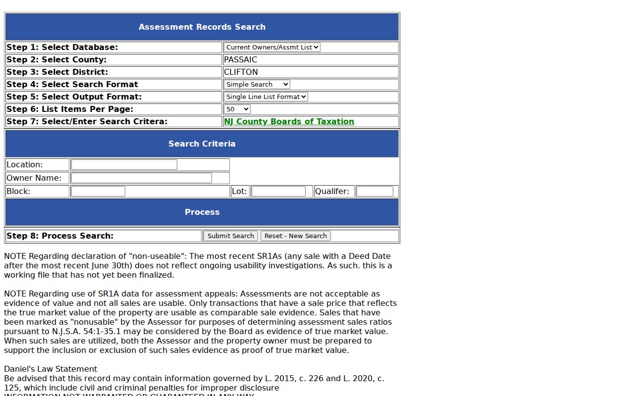
The search controls provide a bridge from a street or owner clue to the block-and-lot identifiers required for a careful neighboring-parcel comparison.
Clifton Neighbor Deed Confirmation
After the assessor identifies a parcel, search the Passaic PRESS land-record system by current owner and, when useful, by block and lot. Read the latest deed or mortgage for grantor and grantee roles, recording date, legal description, book and page or instrument number. A filed map, dedication, right-of-way, or street-vacation document can explain an unexpected parcel edge or street arrangement.
PRESS offers a free public index and first document page. The online index reaches December 1, 2000 to the present, while deed and mortgage images begin January 1, 1989 with older conversion incomplete. The County Clerk cautions that the public system is not a title-search substitute. For complete older material, certified copies, or title work, use the Registry Record Room and the clerk’s published access route.
Note: A recorded owner confirms a document role and parcel trail, not the identity or presence of every neighbor at that address.
Clifton Neighbor Voter Lists
The state registration check is for supplied registration information, not a street browser. Its live fields were blocked during unattended research, so no current field labels, required inputs, filters, results, or non-match message are asserted. The official route for an election-district list is a request to the Passaic elections custodian under N.J.S.A. 19:31-26, which cites $0.25 per copy.
State law describes limited public list content, while signatures, identifying numbers, and protected addresses are not ordinary public output. A statewide system can contain more internal fields than a requester may receive. Use an election-district list only through the statutory route, preserve its restrictions, and do not turn a registration confirmation into a public neighborhood roster.
Clifton Neighborhood Contacts
Clifton’s civic layer is useful for contact and neighborhood vocabulary, not for identifying every household. The city’s Action Clifton Committee is the only inspected umbrella-like neighborhood body. It describes 16 contiguous neighborhoods, with one permanent and one alternate member for each neighborhood. The city page does not publish a complete resident membership directory.
Other city-listed groups may hold newsletters, programs, officer lists, or photographs, but the research did not locate a public HOA member directory. Contact a group through its own public channel and respect organization-controlled rosters. The cards below distinguish useful public contacts from claims about membership.
Action Clifton Committee
Sixteen contiguous neighborhood areas, with permanent and alternate members. Applications go through the City Clerk at 900 Clifton Avenue; meetings are monthly at the Senior Center except July, August, and December.
City Local Organizations
Action Clifton Committee, Clifton Garden Club, Clifton Municipal Alliance/CASA, Clifton Stamp Society, Clifton Avenue of Flags, Boys and Girls Club, Woman’s Club of Allwood, Clifton Cares, and DIAL Recreation are public contact leads, not household lists.
Clifton Public Library
Local-history staff and collections can help with older directories, maps, newspapers, yearbooks, and photographs. Ask about a specific title or street because access varies by collection.
Clifton Neighbor Tool Comparison
Official records and commercial neighbor tools answer different questions. Government sources preserve their own scope, update cycle, and privacy limits. Commercial tools compile mixed public and purchased data into secondary reports. The latter can merge people with the same name, retain old addresses, or omit lawful redactions. For a Clifton neighbors question, begin with the primary custodian and retain the document or parcel identifier that supports the result.
| Category | Best use | Key limitation |
|---|---|---|
| Official parcel and deed records | Confirm a parcel, recorded party role, legal description, or instrument | Do not create a full resident list or prove occupancy |
| Election records | Use the controlled, statutory list route for an election-district record | Protected fields and addresses remain restricted |
| Commercial neighbor reports | Secondary research lead only | May be stale, incomplete, or combine same-name people |
When two sources conflict, prefer the custodian’s current record and compare the specific identifier. A paid report should never replace a map feature, assessor record, recorded instrument, or statutory election request.
Clifton Neighbor Roster Myth
A tax mailing address, deed owner, voter match, and GIS parcel do not combine into a complete household roster. Each describes a different record relationship. A deed can remain in a former owner’s name until a later transfer is recorded. An assessment mailing address can be outside Clifton. A voter confirmation has limited output, and a GIS owner field can be blank or redacted.
That distinction protects both accuracy and privacy. People who rent, board, receive mail elsewhere, live with family, or have protected addresses may not appear in the same records as a property owner. The honest result is sometimes a parcel trail with no public conclusion about who is present.
Clifton Neighborhood Geography
Local neighborhood names can help refine a historic or civic search, but they are not a parcel boundary system. Research sources use names such as Albion Center, Allwood, Athenia, Botany, Clifton Center, Delawanna, Dutch Hill, Lakeview, Richfield, and Rosemawr. Counts and labels vary across city and library material, so they should be treated as local vocabulary rather than legal district lines.
For a map-based Clifton neighbors search, use the GIS geometry and municipality identifiers first. Then retain the neighborhood name only as context for a civic contact, historic directory heading, or local-history request. The city’s health material also notes postal and municipal edge differences, another reason an address label alone should not define the block.
Clifton Neighbor Privacy Limits
Adjacent parcels do not equal adjacent households. Utility, delivery, school-student, and private association information is not a public neighbor list. New Jersey’s Address Confidentiality Program can provide an eligible participant a legal substitute address, while Daniel’s Law can require redaction for covered people and qualifying household members. A blank owner field may be a lawful protection rather than a data error.
OPRA reaches existing, specific government records subject to exemptions and does not require Clifton to build a combined resident roster. Request an address-specific permit, agenda record, or document only when it is relevant, and direct a correction to the office that keeps the source. Do not use public records to reconstruct protected locations or to expose a person’s private details.
Lawful use. Use Clifton neighbor records for personal, lawful research and civic context. Stalking, harassment, intimidation, and threats can be crimes under New Jersey law.
Note: The best block result identifies the parcel source and its limits, rather than guessing about people who do not appear in the public record.